
Make a donation
Gear up for your next adventure:
As an Amazon Associate, this site earns from qualifying purchases at no extra cost to you.
Lammefjorden topographic map
Click on the map to display elevation.
Make a donation
Gear up for your next adventure:
As an Amazon Associate, this site earns from qualifying purchases at no extra cost to you.
Lammefjorden
The draining project began in 1873, but it took until 1943 before the lowest elevations were pumped dry. Large parts of the fjord were shallow enough to be dry early on. In 1899 the Odsherred Railway opened across the western end of the fjord. The town of Fårevejle Stationsby grew up where the railway intersects that main road across the seabed; it serves as the administrative and mercantile center for much of the Lammefjord.
Make a donation
Gear up for your next adventure:
As an Amazon Associate, this site earns from qualifying purchases at no extra cost to you.
About this map
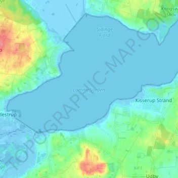
Name: Lammefjorden topographic map, elevation, terrain.
Location: Lammefjorden, Gundestrup, Region Zealand, Denmark (55.77172 11.60912 55.80615 11.73209)
Average elevation: 33 ft
Minimum elevation: -33 ft
Maximum elevation: 200 ft
Make a donation
Gear up for your next adventure:
As an Amazon Associate, this site earns from qualifying purchases at no extra cost to you.