Geolocate

Sherpur topographic map

Click on the map to display elevation.

About this map

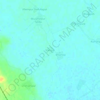
Name: Sherpur topographic map, elevation, terrain.

Location: Sherpur, Kanth, Moradabad, Uttar Pradesh, India (29.00323 78.64816 29.04323 78.68816)

Average elevation: 676 ft

Minimum elevation: 659 ft

Maximum elevation: 741 ft

Gear up for your next adventure:

🧯Portable Fire Pit - Compact fire pit for camping spots
🔭Stargazing Telescopes - Perfect for camping in low-light pollution areas shown on maps
GPS Sports Watch - GPS watch for running, hiking and training
🕶️GPS Smartphone Mount - Secure mount for phone navigation
🪑Ultralight Camp Chairs - Portable seating for resting after a long day of mapping

As an Amazon Associate, this site earns from qualifying purchases at no extra cost to you.