Geolocate

Badiangan topographic map

Click on the map to display elevation.

About this map

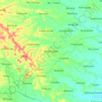
Name: Badiangan topographic map, elevation, terrain.

Location: Badiangan, Iloilo, Western Visayas, 5033, Philippines (10.94634 122.49675 11.02634 122.57675)

Average elevation: 217 ft

Minimum elevation: 102 ft

Maximum elevation: 436 ft

Other topographic maps

Click on a map to view its topography, its elevation and its terrain.

Balasan

Philippines > Iloilo

Average elevation: 138 ft

Banate

Philippines > Iloilo

Average elevation: 112 ft

Miagao

Philippines > Iloilo

Average elevation: 318 ft

Lambunao

Philippines > Iloilo > Lambunao

Average elevation: 417 ft

Anilao

Philippines > Iloilo > Anilao

Average elevation: 171 ft

Bayas Island

Philippines > Iloilo > Estancia > Bayas

Average elevation: 3 ft

Balbagon Island

Philippines > Iloilo > Carles

Average elevation: 0 ft

Leganes

Philippines > Iloilo

Average elevation: 26 ft

Gear up for your next adventure:

🎒Trail Energy Bars - High‑calorie bars for hiking energy
🛶Inflatable Kayak - Portable kayak for rivers, lakes, and expeditions
🔦LED Headlamp - Bright and durable LED headlamp for night navigation
📦Gear Storage Bags - Organize and protect outdoor equipment
🌧️Backpack Rain Cover - Keep gear dry in wet weather

As an Amazon Associate, this site earns from qualifying purchases at no extra cost to you.