Geolocate

Derna topographic map

Click on the map to display elevation.

About this map
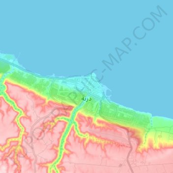
Name: Derna topographic map, elevation, terrain.

Location: Derna, Libya (32.74005 22.55676 32.79145 22.68429)

Average elevation: 285 ft

Minimum elevation: -3 ft

Maximum elevation: 912 ft

Other topographic maps

Click on a map to view its topography, its elevation and its terrain.

AIN MARA

Libya > Derna

Average elevation: 1,506 ft

Al Athrun

Libya > Derna

Average elevation: 374 ft

al Fataieh-Darnah

Libya > Derna

Average elevation: 823 ft

Al Qubbah

Libya > Derna

Average elevation: 1,919 ft

Gear up for your next adventure:

☕Camping Coffee Makers - Enjoy premium coffee at the summit or campsite
❄️Traction Cleats - Prevent slips on icy trails during winter hikes
🛠️Outdoor Gear Repair Kit - Essential tools to fix gear on the trail
🎒Day Hiking Backpack - Lightweight backpack perfect for day trips and outdoor adventures
🧭GPS Watch Accessories - Bands and chargers for GPS watches

As an Amazon Associate, this site earns from qualifying purchases at no extra cost to you.