Geolocate

Kiangan topographic map

Click on the map to display elevation.

About this map
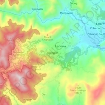
Name: Kiangan topographic map, elevation, terrain.

Location: Kiangan, Ifugao, Cordillera Administrative Region, 3604, Philippines (16.73637 121.04683 16.81637 121.12683)

Average elevation: 2,710 ft

Minimum elevation: 1,322 ft

Maximum elevation: 4,774 ft

Other topographic maps

Click on a map to view its topography, its elevation and its terrain.
Banaue Rice Terraces

Philippines > Ifugao > Banaue > Viewpoint > Pan-ngat

Average elevation: 4,308 ft

Magat River

Philippines > Ifugao

Average elevation: 522 ft

Banaue

Philippines > Ifugao

Average elevation: 4,751 ft

Hapao-Ibulao

Philippines > Ifugao > Bokiawan

Average elevation: 3,547 ft

Bilong

Philippines > Ifugao > Kiangan

Average elevation: 3,225 ft

Ibulao River

Philippines > Ifugao > Hapid

Average elevation: 1,926 ft

Batad Rice Terraces

Philippines > Ifugao > Banaue > Batad

Average elevation: 3,291 ft

Banaue

Philippines > Ifugao

Average elevation: 4,751 ft

Banaue Rice Terraces

Philippines > Ifugao > Banaue > Viewpoint > Pan-ngat

Average elevation: 4,308 ft

Banaue Rice Terraces

Philippines > Ifugao > Banaue > Poblacion

Average elevation: 4,308 ft

Banaue Rice Terraces

Philippines > Ifugao > Banaue > Viewpoint > Pan-ngat

Average elevation: 4,308 ft

Banaue

Philippines > Ifugao

Average elevation: 4,751 ft

Bilong

Philippines > Ifugao > Kiangan

Average elevation: 3,225 ft

Banaue

Philippines > Ifugao

Average elevation: 4,751 ft

Gear up for your next adventure:

🧤Tactile Hiking Gloves - Keep hands warm while operating GPS and smartphone screens
🔪Outdoor Multitools - Essential survival tools for gear repair and field use
🛌Ultralight Sleeping Bags - Compact down bags for cold nights in the wilderness
Camping Coffee Makers - Enjoy premium coffee at the summit or campsite
🔋Solar Power Banks - Keep your GPS and phone charged in remote wilderness areas

As an Amazon Associate, this site earns from qualifying purchases at no extra cost to you.