Geolocate

Calamandrana topographic map

Click on the map to display elevation.

About this map

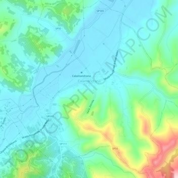
Name: Calamandrana topographic map, elevation, terrain.

Location: Calamandrana, Asti, Piedmont, 14042, Italy (44.71378 8.30998 44.75625 8.36817)

Average elevation: 666 ft

Minimum elevation: 456 ft

Maximum elevation: 1,404 ft

Other topographic maps

Click on a map to view its topography, its elevation and its terrain.

Zolfo

Italy > Piedmont > Asti > Montafia

Average elevation: 741 ft

Gear up for your next adventure:

☀️Outdoor Sunscreen - High protection sunscreen for outdoor activities
🪶Compact Camp Shovel - Folding shovel for campsite tasks
🛠️Backpacking Tool Kit - Essential toolkit for outdoor repairs
⛑️Personal Locator Beacon - Safety beacon for emergencies
🪶Trail Camera - Capture wildlife on your hikes

As an Amazon Associate, this site earns from qualifying purchases at no extra cost to you.