
Thank you for supporting this site ❤️
Make a donation
Make a donation
Gear up for your next adventure:
As an Amazon Associate, this site earns from qualifying purchases at no extra cost to you.
Cuyamapa topographic map
Click on the map to display elevation.
Thank you for supporting this site ❤️
Make a donation
Make a donation
Gear up for your next adventure:
As an Amazon Associate, this site earns from qualifying purchases at no extra cost to you.
About this map
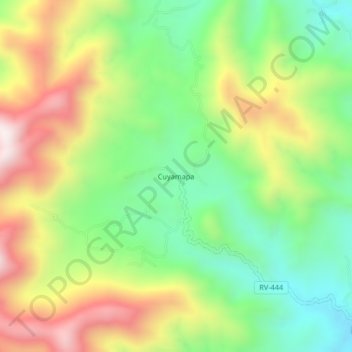
Name: Cuyamapa topographic map, elevation, terrain.
Location: Cuyamapa, Danlí, El Paraíso, Honduras (14.24023 -86.36048 14.28023 -86.32048)
Average elevation: 3,271 ft
Minimum elevation: 2,188 ft
Maximum elevation: 4,774 ft
Thank you for supporting this site ❤️
Make a donation
Make a donation
Gear up for your next adventure:
As an Amazon Associate, this site earns from qualifying purchases at no extra cost to you.
Other topographic maps
Click on a map to view its topography, its elevation and its terrain.
Reserva Natural Cordillera de Dipilto y Jalapa
Honduras > El Paraíso > Danlí
Average elevation: 3,081 ft