
Thank you for supporting this site ❤️
Make a donation
Make a donation
Gear up for your next adventure:
As an Amazon Associate, this site earns from qualifying purchases at no extra cost to you.
Val Soana topographic map
Click on the map to display elevation.
Thank you for supporting this site ❤️
Make a donation
Make a donation
Gear up for your next adventure:
As an Amazon Associate, this site earns from qualifying purchases at no extra cost to you.
Val Soana
La vallée comporte de nombreux lacs d'altitude, le plus important d'entre eux étant le lac Lasin.
Thank you for supporting this site ❤️
Make a donation
Make a donation
Gear up for your next adventure:
As an Amazon Associate, this site earns from qualifying purchases at no extra cost to you.
About this map
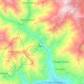
Name: Val Soana topographic map, elevation, terrain.
Location: Val Soana, Ingria, Turin, Piémont, 10085, Italie (45.41847 7.54179 45.52471 7.60473)
Average elevation: 4,777 ft
Minimum elevation: 1,421 ft
Maximum elevation: 9,196 ft
Thank you for supporting this site ❤️
Make a donation
Make a donation
Gear up for your next adventure:
As an Amazon Associate, this site earns from qualifying purchases at no extra cost to you.