Geolocate

Willerby topographic map

Click on the map to display elevation.

About this map

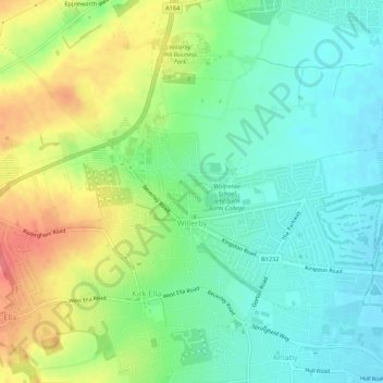
Name: Willerby topographic map, elevation, terrain.

Location: Willerby, East Riding of Yorkshire, England, United Kingdom (53.74883 -0.45776 53.77117 -0.40362)

Average elevation: 92 ft

Minimum elevation: 7 ft

Maximum elevation: 233 ft

Other topographic maps

Click on a map to view its topography, its elevation and its terrain.

Welton

United Kingdom > England > East Riding of Yorkshire

Average elevation: 128 ft

Gear up for your next adventure:

🗺️NatGeo Topo Maps - High-quality waterproof printed topographic maps of US Parks
📶Vehicle Signal Boosters - Improve reception in rural areas while driving to trailheads
🔭Compact Binoculars - HD vision for scouting terrain and identifying distant landmarks
🔋Rechargeable Batteries - Power up your outdoor devices
🔊Portable Camp Speaker - Music and alerts at camp

As an Amazon Associate, this site earns from qualifying purchases at no extra cost to you.