Geolocate

Pinewood topographic map

Click on the map to display elevation.

About this map

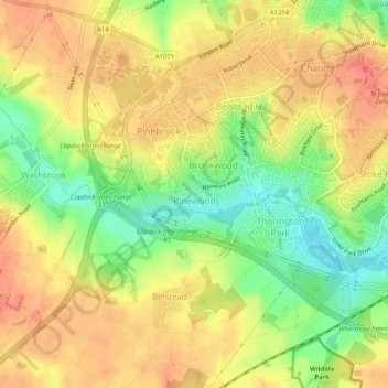
Name: Pinewood topographic map, elevation, terrain.

Location: Pinewood, Washbrook, Babergh, Suffolk, England, United Kingdom (52.02584 1.09561 52.04650 1.14668)

Average elevation: 102 ft

Minimum elevation: 0 ft

Maximum elevation: 171 ft

Gear up for your next adventure:

🎒Trekking Poles - Sturdy poles for balance and stability on rough terrain
🧭GPS Watch Accessories - Bands and chargers for GPS watches
🧼Biodegradable Camping Soap - Eco‑friendly soap for outdoor hygiene
👟Men's Trail Runners - Lightweight footwear for fast-paced exploration and light hiking
Solar GPS Watches - Advanced multisport watches with built-in topographic maps

As an Amazon Associate, this site earns from qualifying purchases at no extra cost to you.