Geolocate

Julian topographic map

Click on the map to display elevation.

About this map

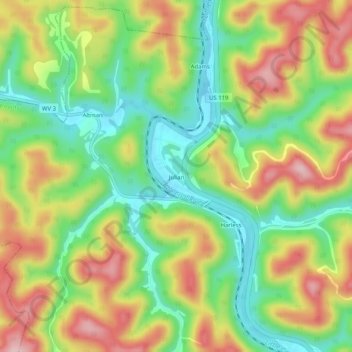
Name: Julian topographic map, elevation, terrain.

Location: Julian, Boone County, West Virginia, 25529, United States (38.13755 -81.87577 38.17755 -81.83577)

Average elevation: 945 ft

Minimum elevation: 630 ft

Maximum elevation: 1,322 ft

Boone County trails, hiking, mountain biking, running and outdoor activities

Other topographic maps

Click on a map to view its topography, its elevation and its terrain.

Whitesville

United States > West Virginia > Boone County

Average elevation: 1,352 ft

Madison

United States > West Virginia > Boone County

Average elevation: 1,066 ft

Danville

United States > West Virginia > Boone County

Average elevation: 919 ft

Sylvester

United States > West Virginia > Boone County

Average elevation: 1,266 ft

Gear up for your next adventure:

🎒Trail Energy Bars - High‑calorie bars for hiking energy
🪑Portable Camp Table - Compact table for campsite meals
🔊Portable Camp Speaker - Music and alerts at camp
📷Action Cameras - Rugged cameras to document your journeys across rugged terrain
🌡️Portable Weather Meter - Track weather conditions on the trail

As an Amazon Associate, this site earns from qualifying purchases at no extra cost to you.