
Village of Warwick topographic map
Interactive map
Click on the map to display elevation.
About this map
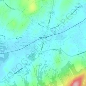
Name: Village of Warwick topographic map, elevation, terrain.
Average elevation: 614 ft
Minimum elevation: 492 ft
Maximum elevation: 1,217 ft
Other topographic maps
Click on a map to view its topography, its elevation and its terrain.
Village of Florida
United States > New York > Orange County > Town of Warwick
Village of Florida, Town of Warwick, Orange County, New York, 10921, United States
Average elevation: 492 ft
Bellvale
United States > New York > Orange County > Town of Warwick
Bellvale, Town of Warwick, Orange County, New York, 10912, United States
Average elevation: 741 ft
Sterling Forest
United States > New York > Orange County > Town of Warwick
Sterling Forest, Town of Warwick, Orange County, New York, 10979, United States
Average elevation: 827 ft