Geolocate

Ortezzano topographic map

Click on the map to display elevation.

About this map

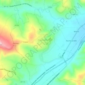
Name: Ortezzano topographic map, elevation, terrain.

Location: Ortezzano, Fermo, Marche, 63851, Italia (43.01210 13.58839 43.04590 13.63113)

Average elevation: 827 ft

Minimum elevation: 554 ft

Maximum elevation: 1,483 ft

Other topographic maps

Click on a map to view its topography, its elevation and its terrain.

Vetice

Italia > Marche > Fermo > Montefortino

Average elevation: 2,320 ft

San Martino al Faggio

Italia > Marche > Fermo > Smerillo

Average elevation: 1,585 ft

Marina Palmense

Italia > Marche > Fermo > Fermo > Torre di Palme

Average elevation: 131 ft

Montazzolino

Italia > Marche > Fermo > Montefortino

Average elevation: 2,047 ft

Gear up for your next adventure:

🎒Outdoor Daypacks - Lightweight backpacks designed for carrying maps and essential gear
🧢Outdoor Hiking Hat - Sun protection hat for outdoor explorers
🚪Portable Camp Chair - Foldable chair for comfort at camp
🦶Carbon Trekking Poles - Reduce knee impact on steep descents with ultra-light poles
🧭Outdoor Navigation Book - Learn advanced navigation skills

As an Amazon Associate, this site earns from qualifying purchases at no extra cost to you.