Geolocate

Monte Resegone topographic map

Click on the map to display elevation.

About this map

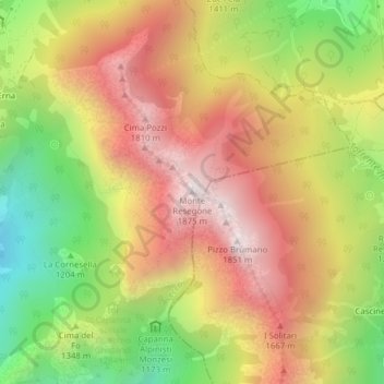
Name: Monte Resegone topographic map, elevation, terrain.

Location: Monte Resegone, Lecco, Lombardy, 23900, Italy (45.85836 9.46881 45.85846 9.46891)

Average elevation: 4,498 ft

Minimum elevation: 2,694 ft

Maximum elevation: 6,079 ft

Gear up for your next adventure:

🧭GPS Watch Accessories - Bands and chargers for GPS watches
👟Men's Trail Runners - Lightweight footwear for fast-paced exploration and light hiking
🔥Plasma Lighters - Windproof lighters that work in any weather condition
🪵Folding Camp Saw - Compact saw for wood and campsite work
🔊Portable Camp Speaker - Music and alerts at camp

As an Amazon Associate, this site earns from qualifying purchases at no extra cost to you.