
Thank you for supporting this site ❤️
Make a donation
Make a donation
Gear up for your next adventure:
As an Amazon Associate, this site earns from qualifying purchases at no extra cost to you.
Rauhenebrach topographic map
Click on the map to display elevation.
Thank you for supporting this site ❤️
Make a donation
Make a donation
Gear up for your next adventure:
As an Amazon Associate, this site earns from qualifying purchases at no extra cost to you.
Rauhenebrach
mit einem BHU (Brusthöhenumfang) von 7,20 m. ⊙49.87613110.593019
Thank you for supporting this site ❤️
Make a donation
Make a donation
Gear up for your next adventure:
As an Amazon Associate, this site earns from qualifying purchases at no extra cost to you.
About this map
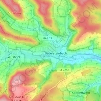
Name: Rauhenebrach topographic map, elevation, terrain.
Location: Rauhenebrach, Landkreis Haßberge, Bayern, 96181, Deutschland (49.86965 10.52932 49.90965 10.56932)
Average elevation: 1,181 ft
Minimum elevation: 971 ft
Maximum elevation: 1,440 ft
Thank you for supporting this site ❤️
Make a donation
Make a donation
Gear up for your next adventure:
As an Amazon Associate, this site earns from qualifying purchases at no extra cost to you.