
Thank you for supporting this site ❤️
Make a donation
Make a donation
Gear up for your next adventure:
As an Amazon Associate, this site earns from qualifying purchases at no extra cost to you.
Belchite topographic map
Click on the map to display elevation.
Thank you for supporting this site ❤️
Make a donation
Make a donation
Gear up for your next adventure:
As an Amazon Associate, this site earns from qualifying purchases at no extra cost to you.
About this map
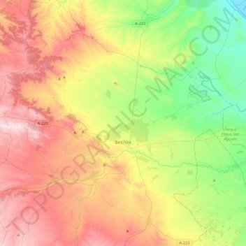
Name: Belchite topographic map, elevation, terrain.
Location: Belchite, Campo de Belchite, Zaragoza, Aragon, 50130, Spain (41.23685 -0.86825 41.42425 -0.44430)
Average elevation: 1,532 ft
Minimum elevation: 518 ft
Maximum elevation: 2,818 ft
Thank you for supporting this site ❤️
Make a donation
Make a donation
Gear up for your next adventure:
As an Amazon Associate, this site earns from qualifying purchases at no extra cost to you.