
Thank you for supporting this site ❤️
Make a donation
Make a donation
Gear up for your next adventure:
As an Amazon Associate, this site earns from qualifying purchases at no extra cost to you.
Whroo topographic map
Click on the map to display elevation.
Thank you for supporting this site ❤️
Make a donation
Make a donation
Gear up for your next adventure:
As an Amazon Associate, this site earns from qualifying purchases at no extra cost to you.
About this map
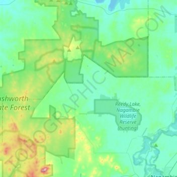
Name: Whroo topographic map, elevation, terrain.
Location: Whroo, Shire of Strathbogie, Victoria, 3612, Australia (-36.74548 144.93197 -36.63068 145.17399)
Average elevation: 505 ft
Minimum elevation: 374 ft
Maximum elevation: 1,010 ft
Thank you for supporting this site ❤️
Make a donation
Make a donation
Gear up for your next adventure:
As an Amazon Associate, this site earns from qualifying purchases at no extra cost to you.