Geolocate

Murnisari topographic map

Click on the map to display elevation.

About this map

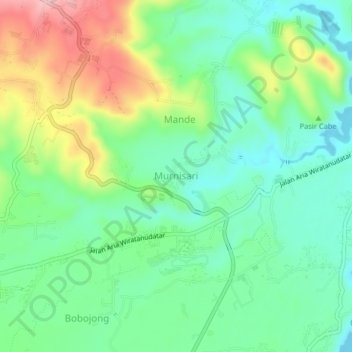
Name: Murnisari topographic map, elevation, terrain.

Location: Murnisari, Cianjur, West Java, Java, Indonesia (-6.77716 107.21791 -6.73716 107.25791)

Average elevation: 899 ft

Minimum elevation: 699 ft

Maximum elevation: 1,293 ft

Other topographic maps

Click on a map to view its topography, its elevation and its terrain.

Kertajadi

Indonesia > West Java > Cianjur

Average elevation: 354 ft

Agrabinta

Indonesia > West Java > Cianjur

Average elevation: 354 ft

Cidaun

Indonesia > West Java > Cianjur

Average elevation: 2,159 ft

Karangwangi

Indonesia > West Java > Cianjur

Average elevation: 390 ft

Wanasari

Indonesia > West Java > Cianjur

Average elevation: 102 ft

Jayapura

Indonesia > West Java > Cianjur

Average elevation: 240 ft

Cisalak

Indonesia > West Java > Cianjur

Average elevation: 161 ft

Gear up for your next adventure:

🏫Relief Map Kits - Hands-on tools for teaching landforms and elevation
🪶LED Camping Lantern - Bright lantern for camp lighting
🔭Stargazing Telescopes - Perfect for camping in low-light pollution areas shown on maps
🖼️Topo Map Wall Art - Decorative topographic prints of famous peaks and regions
🌧️Backpack Rain Cover - Keep gear dry in wet weather

As an Amazon Associate, this site earns from qualifying purchases at no extra cost to you.