Geolocate

Borlongan topographic map

Click on the map to display elevation.

About this map

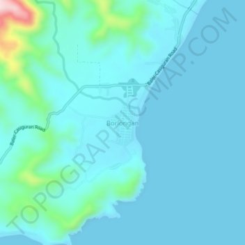
Name: Borlongan topographic map, elevation, terrain.

Location: Borlongan, Aurora, Central Luzon, Philippines (15.96548 121.63062 16.00548 121.67062)

Average elevation: 128 ft

Minimum elevation: 0 ft

Maximum elevation: 1,129 ft

Other topographic maps

Click on a map to view its topography, its elevation and its terrain.

Baler

Philippines > Aurora

Average elevation: 200 ft

Dingalan

Philippines > Aurora

Average elevation: 817 ft

Dicasalarin Cove

Philippines > Aurora > Baler

Average elevation: 253 ft

Dingalan River

Philippines > Aurora > Dingalan

Average elevation: 617 ft

Aguang River

Philippines > Aurora > Baler

Average elevation: 118 ft

Quezon Memorial Park

Philippines > Aurora > Baler > Sabang

Average elevation: 20 ft

Umiray River

Philippines > Aurora > Dingalan > Abungan

Average elevation: 305 ft

Casapsapan Beach

Philippines > Aurora > Casiguran > Dipasaleng

Average elevation: 72 ft

Dingalan

Philippines > Aurora

Average elevation: 817 ft

Dingalan

Philippines > Aurora

Average elevation: 817 ft

Dingalan

Philippines > Aurora

Average elevation: 817 ft

Baler

Philippines > Aurora

Average elevation: 200 ft

Gear up for your next adventure:

🚁Photography Drones - Capture stunning aerial views of landforms and topography
🌲Outdoor Survival Books - Best books on survival skills
🪶Trail Camera - Capture wildlife on your hikes
📡GPS Antenna Upgrade - Enhance GPS reception in remote terrain
🎒Outdoor Daypacks - Lightweight backpacks designed for carrying maps and essential gear

As an Amazon Associate, this site earns from qualifying purchases at no extra cost to you.