Geolocate

Maroun Al Ras topographic map

Click on the map to display elevation.

Maroun Al Ras

Maroun al-Ras is strategically important as it overlooks the surrounding towns. The village's elevation is 911 meters (2,989 feet).

Wikipedia (CC-BY-SA 3.0)

About this map

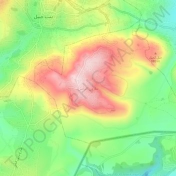
Name: Maroun Al Ras topographic map, elevation, terrain.

Location: Maroun Al Ras, Maroun Er Ras, Bint Jbeil District, Nabatieh Governorate, Lebanon (33.08309 35.42496 33.12309 35.46496)

Average elevation: 2,516 ft

Minimum elevation: 2,024 ft

Maximum elevation: 3,100 ft

Other topographic maps

Click on a map to view its topography, its elevation and its terrain.

Beaufort Castle

Lebanon > Nabatieh Governorate > Klayaa

Average elevation: 1,568 ft

Meiss Ej-Jabal

Lebanon > Nabatieh Governorate

Average elevation: 2,067 ft

Klayaa

Lebanon > Nabatieh Governorate

The village sits on a ridge at an elevation estimated between 650 and 700 meters (2,130–2,300 ft) above sea level.[4][5][6] Its position places it within the hilly landscape of the Upper Galilee region, an area characterized by rolling highlands and valleys typical of southern Lebanese terrain. Al-Qlaiaah…

Average elevation: 1,709 ft

Haddatha

Lebanon > Nabatieh Governorate

Average elevation: 2,425 ft

Khiam

Lebanon > Nabatieh Governorate

Average elevation: 1,703 ft

Marjayoun

Lebanon > Nabatieh Governorate

Average elevation: 2,136 ft

Bint Jbail

Lebanon > Nabatieh Governorate

Average elevation: 2,559 ft

Meiss Ej-Jabal

Lebanon > Nabatieh Governorate

Average elevation: 2,067 ft

Bayt Lif

Lebanon > Nabatieh Governorate

Average elevation: 1,919 ft

Bint Jbeil District

Lebanon > Nabatieh Governorate

Average elevation: 1,673 ft

Baraachit

Lebanon > Nabatieh Governorate

Average elevation: 2,201 ft

Taibeh

Lebanon > Nabatieh Governorate

Average elevation: 1,703 ft

Deir El Zahrani

Lebanon > Nabatieh Governorate

Average elevation: 1,263 ft

Aali Et Taher

Lebanon > Nabatieh Governorate

Average elevation: 1,696 ft

Tibnine

Lebanon > Nabatieh Governorate

Average elevation: 2,054 ft

Shebaa

Lebanon > Nabatieh Governorate

Average elevation: 4,806 ft

Majdel Selm

Lebanon > Nabatieh Governorate

Average elevation: 1,749 ft

Marjayoun

Lebanon > Nabatieh Governorate

Average elevation: 2,136 ft

Kafr Kila

Lebanon > Nabatieh Governorate

The total population of the village is about 14,500. The occupants' number increases dramatically during summer. Its altitude is around 700 m from sea level.

Average elevation: 1,847 ft

Ansar

Lebanon > Nabatieh Governorate

Average elevation: 702 ft

Majdel Selm

Lebanon > Nabatieh Governorate

Average elevation: 1,749 ft

Markaba

Lebanon > Nabatieh Governorate

Average elevation: 2,192 ft

Khiam

Lebanon > Nabatieh Governorate

Average elevation: 1,703 ft

Odaisseh

Lebanon > Nabatieh Governorate

Average elevation: 2,133 ft

Baraachit

Lebanon > Nabatieh Governorate

Average elevation: 2,201 ft

Froun

Lebanon > Nabatieh Governorate

Average elevation: 902 ft

Blat

Lebanon > Nabatieh Governorate

Average elevation: 2,139 ft

Souaneh

Lebanon > Nabatieh Governorate

Average elevation: 1,631 ft

Haris

Lebanon > Nabatieh Governorate

Average elevation: 2,185 ft

Markaba

Lebanon > Nabatieh Governorate

Average elevation: 2,192 ft

Bani Haiyane

Lebanon > Nabatieh Governorate

Average elevation: 1,562 ft

Rachaiya El Foukhar

Lebanon > Nabatieh Governorate

Average elevation: 2,028 ft

al sanawbar

Lebanon > Nabatieh Governorate > Rmaich

Average elevation: 2,051 ft

Chaqra

Lebanon > Nabatieh Governorate

Average elevation: 2,087 ft

Gear up for your next adventure:

🌧️Backpack Rain Cover - Keep gear dry in wet weather
🧥Men's Rain Shells - Premium waterproof and breathable jackets for mountain weather
🌄Hiking Binoculars - Compact binoculars for scenic views and trail spotting
🪶Survival Guide Book - Expert advice for emergency preparedness
📌Outdoor GPS Map App - Apps and devices for digital topographic navigation

As an Amazon Associate, this site earns from qualifying purchases at no extra cost to you.