
Make a donation
Gear up for your next adventure:
As an Amazon Associate, this site earns from qualifying purchases at no extra cost to you.
Monte Terminillo topographic map
Click on the map to display elevation.
Make a donation
Gear up for your next adventure:
As an Amazon Associate, this site earns from qualifying purchases at no extra cost to you.
Monte Terminillo
Monte Terminillo is a massif in the Monti Reatini, part of the Abruzzi Apennine range in central Italy. It is located some 20 km from Rieti and 100 km from Rome and has a highest altitude of 2,217 metres (7,274 ft).
Make a donation
Gear up for your next adventure:
As an Amazon Associate, this site earns from qualifying purchases at no extra cost to you.
About this map
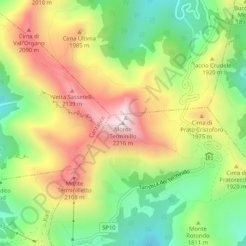
Name: Monte Terminillo topographic map, elevation, terrain.
Location: Monte Terminillo, Micigliano, Rieti, Lazio, Italy (42.47325 12.99731 42.47335 12.99741)
Average elevation: 6,017 ft
Minimum elevation: 5,010 ft
Maximum elevation: 7,221 ft
Make a donation
Gear up for your next adventure:
As an Amazon Associate, this site earns from qualifying purchases at no extra cost to you.