Geolocate
👉 Easily get elevation data in JSON, GeoTIFF and KML formats using Elevation API
Thank you for supporting this site ❤️
Make a donation

Marshall topographic map

Click on the map to display elevation.

About this map

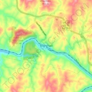
Name: Marshall topographic map, elevation, terrain.

Location: Marshall, Madison County, North Carolina, United States (35.77862 -82.71188 35.81582 -82.64689)

Average elevation: 1,998 ft

Minimum elevation: 1,585 ft

Maximum elevation: 2,457 ft

Madison County trails, hiking, mountain biking, running and outdoor activities

Other topographic maps

Click on a map to view its topography, its elevation and its terrain.

Hurricane

United States > North Carolina > Madison County

Average elevation: 2,103 ft

Allegheny

United States > North Carolina > Madison County

Average elevation: 2,615 ft

Walnut

United States > North Carolina > Madison County

Average elevation: 1,965 ft

Barnard

United States > North Carolina > Madison County

Average elevation: 1,972 ft

Mars Hill

United States > North Carolina > Madison County > Mars Hill

Average elevation: 2,323 ft

Gear up for your next adventure:

☀️Outdoor Sunscreen - High protection sunscreen for outdoor activities
🥤Water Filter Bottle - All‑in‑one filter bottle for safe hydration
🎒Outdoor Daypacks - Lightweight backpacks designed for carrying maps and essential gear
🧭Pro Hiking Compasses - High-accuracy liquid-filled compasses for topographic orientation
🦺Reflective Outdoor Gear - Safety gear for low‑light conditions

As an Amazon Associate, this site earns from qualifying purchases at no extra cost to you.