Geolocate

Kitsilano topographic map

Click on the map to display elevation.

About this map

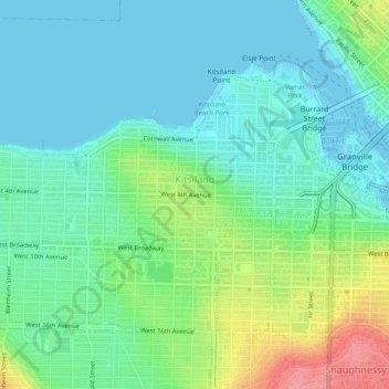
Name: Kitsilano topographic map, elevation, terrain.

Location: Kitsilano, Vancouver, Metro Vancouver Regional District, British Columbia, Canada (49.25717 -123.18614 49.27921 -123.13883)

Average elevation: 79 ft

Minimum elevation: -10 ft

Maximum elevation: 282 ft

Other topographic maps

Click on a map to view its topography, its elevation and its terrain.

Gear up for your next adventure:

🔊Portable Camp Speaker - Music and alerts at camp
📖Nature Tracking Books - Learn to track wildlife and terrain
☀️Outdoor Sunscreen - High protection sunscreen for outdoor activities
🎒Waterproof Dry Bags - Keep your electronics and maps dry inside your pack
🕶️Glacier Sunglasses - Side shields to protect eyes from high-altitude snow glare

As an Amazon Associate, this site earns from qualifying purchases at no extra cost to you.