
Rocha dos Soídos topographic map
Interactive map
Click on the map to display elevation.
About this map
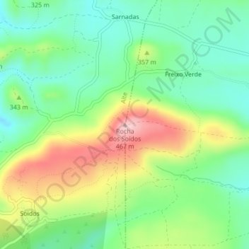
Name: Rocha dos Soídos topographic map, elevation, terrain.
Location: Rocha dos Soídos, Alte, Loulé, Faro, Algarve, Portugal (37.25681 -8.15359 37.25691 -8.15349)
Average elevation: 1,047 ft
Minimum elevation: 778 ft
Maximum elevation: 1,503 ft
Other topographic maps
Click on a map to view its topography, its elevation and its terrain.
Rocha Amarela
Rocha Amarela, Alte, Loulé, Faro, Algarve, Portugal
Average elevation: 577 ft
Águas Frias de Cima
Portugal > Algarve > Alte > Águas Frias de Cima
Águas Frias de Cima, Alte, Loulé, Faro, Algarve, Portugal
Average elevation: 863 ft
Serra da Raiva
Serra da Raiva, Alte, Loulé, Faro, Algarve, Portugal
Average elevation: 912 ft