
Make a donation
Gear up for your next adventure:
As an Amazon Associate, this site earns from qualifying purchases at no extra cost to you.
Venafro topographic map
Click on the map to display elevation.
Make a donation
Gear up for your next adventure:
As an Amazon Associate, this site earns from qualifying purchases at no extra cost to you.
Venafro
La ville se trouve sur une plaine à une altitude de 200 mètres, et est bordée à l'Ouest par des montagnes d'environ 800 à 1100 mètres. Elle est bordée à l'Est par le Volturno.
Make a donation
Gear up for your next adventure:
As an Amazon Associate, this site earns from qualifying purchases at no extra cost to you.
About this map
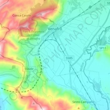
Name: Venafro topographic map, elevation, terrain.
Location: Venafro, Isernia, Molise, 86079, Italie (41.41923 13.97790 41.50256 14.10388)
Average elevation: 1,165 ft
Minimum elevation: 404 ft
Maximum elevation: 3,543 ft
Make a donation
Gear up for your next adventure:
As an Amazon Associate, this site earns from qualifying purchases at no extra cost to you.