
Thank you for supporting this site ❤️
Make a donation
Make a donation
Gear up for your next adventure:
As an Amazon Associate, this site earns from qualifying purchases at no extra cost to you.
Loreto topographic map
Click on the map to display elevation.
Thank you for supporting this site ❤️
Make a donation
Make a donation
Gear up for your next adventure:
As an Amazon Associate, this site earns from qualifying purchases at no extra cost to you.
About this map
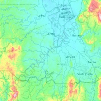
Name: Loreto topographic map, elevation, terrain.
Location: Loreto, Agusan del Sur, Caraga, 8507, Philippines (7.94540 125.37497 8.25834 125.89079)
Average elevation: 371 ft
Minimum elevation: 33 ft
Maximum elevation: 2,592 ft
Thank you for supporting this site ❤️
Make a donation
Make a donation
Gear up for your next adventure:
As an Amazon Associate, this site earns from qualifying purchases at no extra cost to you.