Geolocate

Dortmund topographic map

Click on the map to display elevation.

About this map

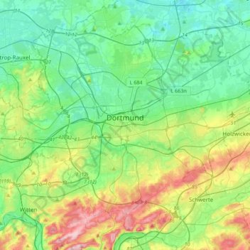
Name: Dortmund topographic map, elevation, terrain.

Location: Dortmund, North Rhine-Westphalia, Germany (51.41553 7.30239 51.60004 7.63816)

Average elevation: 354 ft

Minimum elevation: 144 ft

Maximum elevation: 896 ft

Other topographic maps

Click on a map to view its topography, its elevation and its terrain.

Beyenburg

Germany > North Rhine-Westphalia > Wuppertal

Average elevation: 919 ft

W8

Germany > North Rhine-Westphalia > Kreis Borken > Bocholt

Average elevation: 105 ft

Marmagen

Germany > North Rhine-Westphalia > Kreis Euskirchen

Average elevation: 1,749 ft

Rinne

Germany > North Rhine-Westphalia > Kreis Düren > Kreuzau

Average elevation: 515 ft

Gear up for your next adventure:

🔭Telescopic Hiking Pole - Adjustable pole for hiking stability
🎒Day Hiking Backpack - Lightweight backpack perfect for day trips and outdoor adventures
📚Navigation Handbooks - Master the art of reading topographic maps and using a compass
🔦Compact Flashlight - Reliable flashlight for emergencies
🎒Hydration Pack - Hands‑free water reservoir for long hikes

As an Amazon Associate, this site earns from qualifying purchases at no extra cost to you.