Geolocate

Kugti topographic map

Click on the map to display elevation.

About this map

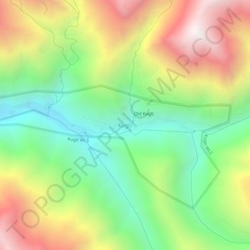
Name: Kugti topographic map, elevation, terrain.

Location: Kugti, Brahmaur, Chamba, Himachal Pradesh, India (32.44984 76.68454 32.48984 76.72454)

Average elevation: 10,184 ft

Minimum elevation: 8,005 ft

Maximum elevation: 13,146 ft

Other topographic maps

Click on a map to view its topography, its elevation and its terrain.

Gauri Kund

India > Himachal Pradesh > Brahmaur

Average elevation: 13,730 ft

Hadsar

India > Himachal Pradesh > Brahmaur

Average elevation: 7,877 ft

Bharmour

India > Himachal Pradesh > Brahmaur

Average elevation: 7,231 ft

Gear up for your next adventure:

🗃️Trail First Aid Kit - Essential kit for outdoor injuries and emergencies
📱Solar Portable Charger - Solar power bank for charging devices off‑grid
🧦Hiking Socks - Comfortable socks to prevent blisters on long hikes
🦟Ultrasonic Repellers - Create a bug-free zone at your camp or rest stop
🚗GPS Dash Cams - Record your scenic drives through mountain passes and canyons

As an Amazon Associate, this site earns from qualifying purchases at no extra cost to you.