
Make a donation
Gear up for your next adventure:
As an Amazon Associate, this site earns from qualifying purchases at no extra cost to you.
Terrassa topographic map
Click on the map to display elevation.
Make a donation
Gear up for your next adventure:
As an Amazon Associate, this site earns from qualifying purchases at no extra cost to you.
Terrassa
The city is located in the Catalan Prelitoral depression (Depressió Prelitoral), at the feet of the Prelitoral mountain range (natural reserve of Sant Llorenç del Munt [ca]) and the average altitude of the city is 277 meters above sea level. It is 20 and 18 kilometres from Barcelona and Montserrat respectively.
Make a donation
Gear up for your next adventure:
As an Amazon Associate, this site earns from qualifying purchases at no extra cost to you.
About this map
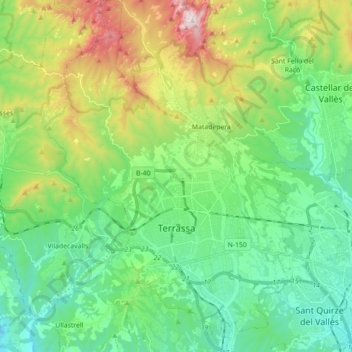
Name: Terrassa topographic map, elevation, terrain.
Location: Terrassa, Vallès Occidental, Barcelona, Catalonia, Spain (41.51630 1.94358 41.64872 2.06882)
Average elevation: 1,257 ft
Minimum elevation: 305 ft
Maximum elevation: 3,576 ft
Make a donation
Gear up for your next adventure:
As an Amazon Associate, this site earns from qualifying purchases at no extra cost to you.
Other topographic maps
Click on a map to view its topography, its elevation and its terrain.