
Somerset topographic map
Click on the map to display elevation.
Somerset
Somerset has the ninth-highest elevation of towns in Pennsylvania, at 2,190 feet (670 m) above sea level. Somerset County is in Appalachia.
About this map
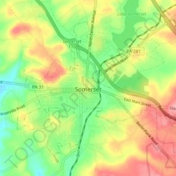
Name: Somerset topographic map, elevation, terrain.
Location: Somerset, Somerset County, Pennsylvania, United States (39.98958 -79.10472 40.02786 -79.03876)
Average elevation: 2,172 ft
Minimum elevation: 1,995 ft
Maximum elevation: 2,375 ft
Somerset County trails, hiking, mountain biking, running and outdoor activities
Other topographic maps
Click on a map to view its topography, its elevation and its terrain.
Pike's Peak
United States > Pennsylvania > Somerset County > Jenner Township
Average elevation: 2,684 ft
Kantner
United States > Pennsylvania > Somerset County > Quemahoning Township
Average elevation: 1,995 ft
Hollsopple
United States > Pennsylvania > Somerset County > Conemaugh Township
Average elevation: 1,788 ft
Listie
United States > Pennsylvania > Somerset County > Somerset Township > Listie
Average elevation: 2,238 ft
Boynton
United States > Pennsylvania > Somerset County > Elk Lick Township > Boynton
Average elevation: 2,152 ft
Bearwallow Mountain
United States > Pennsylvania > Somerset County > Fairhope Township
Average elevation: 2,165 ft
Ralphton
United States > Pennsylvania > Somerset County > Quemahoning Township > Ralphton
Average elevation: 2,087 ft