Geolocate

Crowsnest Pass topographic map

Click on the map to display elevation.

About this map

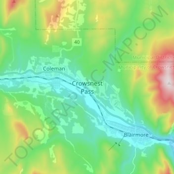
Name: Crowsnest Pass topographic map, elevation, terrain.

Location: Crowsnest Pass, Municipality of Crowsnest Pass, Division No. 15, Alberta, T0K 0E0, Canada (49.58906 -114.51286 49.66906 -114.43286)

Average elevation: 4,961 ft

Minimum elevation: 4,173 ft

Maximum elevation: 7,008 ft

Other topographic maps

Click on a map to view its topography, its elevation and its terrain.

Bow Lake

Canada > Alberta > Division No. 15

Bow Lake is a small lake in western Alberta, Canada. It is located on the Bow River, in the Canadian Rockies, at an altitude of 1920 m.

Average elevation: 7,103 ft

Jasper National Park

Canada > Alberta > Division No. 15

Average elevation: 5,846 ft

Gear up for your next adventure:

🧭Orienteering Set - Complete compass and map reading kit
💧Water Purification System - Clean water on the trail with reliable purifiers
🎒Waterproof Dry Bags - Keep your electronics and maps dry inside your pack
⛑️Personal Locator Beacon - Safety beacon for emergencies
🪶Camp Gear Gift Set - Perfect gift bundle for outdoor fans

As an Amazon Associate, this site earns from qualifying purchases at no extra cost to you.