
Make a donation
Gear up for your next adventure:
As an Amazon Associate, this site earns from qualifying purchases at no extra cost to you.
Adam Peak topographic map
Click on the map to display elevation.
Make a donation
Gear up for your next adventure:
As an Amazon Associate, this site earns from qualifying purchases at no extra cost to you.
About this map
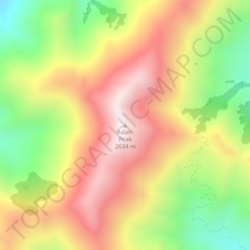
Name: Adam Peak topographic map, elevation, terrain.
Location: Adam Peak, Humboldt County, Nevada, United States (41.16041 -117.30517 41.16051 -117.30507)
Average elevation: 7,415 ft
Minimum elevation: 6,086 ft
Maximum elevation: 8,625 ft
Make a donation
Gear up for your next adventure:
As an Amazon Associate, this site earns from qualifying purchases at no extra cost to you.
Other topographic maps
Click on a map to view its topography, its elevation and its terrain.
North Jackson Mountains Wilderness
United States > Nevada > Humboldt County
Average elevation: 5,732 ft
Make a donation
Gear up for your next adventure:
As an Amazon Associate, this site earns from qualifying purchases at no extra cost to you.
Make a donation
Gear up for your next adventure:
As an Amazon Associate, this site earns from qualifying purchases at no extra cost to you.