Geolocate

Nelsonville topographic map

Click on the map to display elevation.

About this map

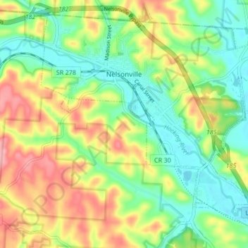
Name: Nelsonville topographic map, elevation, terrain.

Location: Nelsonville, Trimble Township, Athens County, Ohio, 45764, United States (39.42514 -82.25432 39.47122 -82.18716)

Average elevation: 810 ft

Minimum elevation: 650 ft

Maximum elevation: 1,040 ft

Athens County trails, hiking, mountain biking, running and outdoor activities

Other topographic maps

Click on a map to view its topography, its elevation and its terrain.

Stringtown

United States > Ohio > Athens County

Average elevation: 755 ft

La Mar Heights

United States > Ohio > Athens County > Athens

Average elevation: 781 ft

Hockingport

United States > Ohio > Athens County

Average elevation: 689 ft

Shade

United States > Ohio > Athens County

Average elevation: 846 ft

La Mar Heights

United States > Ohio > Athens County > Athens

Average elevation: 781 ft

Millfield

United States > Ohio > Athens County > Millfield

Average elevation: 778 ft

Gear up for your next adventure:

🛡️Insect Repellent - Protection against bugs during outdoor activities
🔋Solar Power Banks - Keep your GPS and phone charged in remote wilderness areas
🧭Map Reading Tools - Tools and kits for map navigation
📡GPS Antenna Upgrade - Enhance GPS reception in remote terrain
🪓Survival Multi‑Tool - Versatile tool for camp and trail tasks

As an Amazon Associate, this site earns from qualifying purchases at no extra cost to you.