Geolocate

Pasig topographic map

Click on the map to display elevation.

About this map

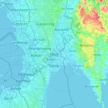
Name: Pasig topographic map, elevation, terrain.

Location: Pasig, Metro Manila, 1601, Philippines (14.40052 120.91671 14.72052 121.23671)

Average elevation: 151 ft

Minimum elevation: -10 ft

Maximum elevation: 1,827 ft

Other topographic maps

Click on a map to view its topography, its elevation and its terrain.

Pasig River

Philippines > Pasig

Average elevation: 46 ft

Ortigas Park

Philippines > Pasig

Average elevation: 118 ft

Pasig City Cemetery

Philippines > Pasig

Average elevation: 30 ft

Parian Creek

Philippines > Pasig

Average elevation: 20 ft

Bridgetowne Central Park

Philippines > Pasig

Average elevation: 36 ft

Parian Creek

Philippines > Pasig

Average elevation: 20 ft

Gear up for your next adventure:

🪓Survival Multi‑Tool - Versatile tool for camp and trail tasks
🧴Hand Sanitizer - Keep hands clean while hiking
🪶Wildlife Field Guides - Learn animal tracking and species ID
🛰️Handheld GPS Units - Professional satellite navigators for precise backcountry mapping
🧺Microfiber Travel Towels - Compact and fast-drying towels for trail use

As an Amazon Associate, this site earns from qualifying purchases at no extra cost to you.