Geolocate

Deventer topographic map

Click on the map to display elevation.

About this map

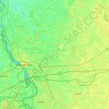
Name: Deventer topographic map, elevation, terrain.

Location: Deventer, Overijssel, Netherlands (52.21744 6.10132 52.32112 6.38191)

Average elevation: 26 ft

Minimum elevation: -10 ft

Maximum elevation: 56 ft

Other topographic maps

Click on a map to view its topography, its elevation and its terrain.

Enschede

Netherlands > Overijssel > Enschede

Average elevation: 112 ft

Witteberg

Netherlands > Overijssel

Average elevation: 187 ft

Zuurberg

Netherlands > Overijssel > Holten

Average elevation: 56 ft

Tankenberg

Netherlands > Overijssel > de Lutte

Average elevation: 190 ft

Helhuizen

Netherlands > Overijssel > Holten

Average elevation: 66 ft

Usselo

Netherlands > Overijssel > Enschede

Average elevation: 102 ft

Frankhuis

Netherlands > Overijssel > Zwolle

Average elevation: 10 ft

Gear up for your next adventure:

🧼Biodegradable Camping Soap - Eco‑friendly soap for outdoor hygiene
🌡️Portable Weather Meter - Track weather conditions on the trail
🪶Trail Camera - Capture wildlife on your hikes
GPS Sports Watch - GPS watch for running, hiking and training
🧥Waterproof Jacket for Hiking - Breathable and rugged rain jacket for outdoor excursions

As an Amazon Associate, this site earns from qualifying purchases at no extra cost to you.