
Make a donation
Gear up for your next adventure:
As an Amazon Associate, this site earns from qualifying purchases at no extra cost to you.
Le Chazelet topographic map
Click on the map to display elevation.
Make a donation
Gear up for your next adventure:
As an Amazon Associate, this site earns from qualifying purchases at no extra cost to you.
About this map
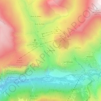
Name: Le Chazelet topographic map, elevation, terrain.
Average elevation: 6,099 ft
Minimum elevation: 4,341 ft
Maximum elevation: 8,015 ft
Make a donation
Gear up for your next adventure:
As an Amazon Associate, this site earns from qualifying purchases at no extra cost to you.
Other topographic maps
Click on a map to view its topography, its elevation and its terrain.
Glacier du Tabuchet
France > Provence-Alpes-Côte d'Azur > Hautes-Alpes > La Grave
Average elevation: 10,095 ft
Glacier de la Meije
France > Provence-Alpes-Côte d'Azur > Hautes-Alpes > La Grave
Average elevation: 10,056 ft
Glacier de la Girose
France > Provence-Alpes-Côte d'Azur > Hautes-Alpes > La Grave
Average elevation: 10,010 ft
Glacier de l'Homme
France > Provence-Alpes-Côte d'Azur > Hautes-Alpes > La Grave
Average elevation: 10,397 ft
Make a donation
Gear up for your next adventure:
As an Amazon Associate, this site earns from qualifying purchases at no extra cost to you.
Refuge du Pic du Mas de la Grave
France > Provence-Alpes-Côte d'Azur > Hautes-Alpes > La Grave > Rivet du Pied
Average elevation: 6,952 ft