
Make a donation
Gear up for your next adventure:
As an Amazon Associate, this site earns from qualifying purchases at no extra cost to you.
Siula Grande topographic map
Click on the map to display elevation.
Make a donation
Gear up for your next adventure:
As an Amazon Associate, this site earns from qualifying purchases at no extra cost to you.
Siula Grande
Siula Grande é um pico da cordilheira dos Andes localizado entre as regiões de Lima e Huánuco no Peru a 6345 metros de altitude.
Make a donation
Gear up for your next adventure:
As an Amazon Associate, this site earns from qualifying purchases at no extra cost to you.
About this map
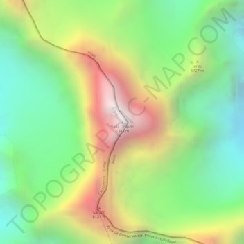
Name: Siula Grande topographic map, elevation, terrain.
Location: Siula Grande, Copa, Cajatambo, Lima, Peru (-10.29479 -76.89172 -10.29469 -76.89162)
Average elevation: 18,130 ft
Minimum elevation: 16,171 ft
Maximum elevation: 20,738 ft
Make a donation
Gear up for your next adventure:
As an Amazon Associate, this site earns from qualifying purchases at no extra cost to you.