
Uffington topographic map
Click on the map to display elevation.
About this map
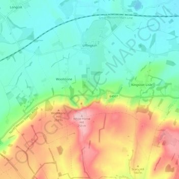
Name: Uffington topographic map, elevation, terrain.
Average elevation: 453 ft
Minimum elevation: 230 ft
Maximum elevation: 856 ft
Other topographic maps
Click on a map to view its topography, its elevation and its terrain.
Lamborough Hill
United Kingdom > England > Oxfordshire > Vale of White Horse > Wootton
Average elevation: 302 ft
Boars Hill
United Kingdom > England > Oxfordshire > Vale of White Horse > Wootton
Average elevation: 348 ft
The Spinney
United Kingdom > England > Oxfordshire > Vale of White Horse > Kingston Bagpuize
Average elevation: 253 ft
Kingston Bagpuize
United Kingdom > England > Oxfordshire > Vale of White Horse
Average elevation: 249 ft
Carswell Marsh
United Kingdom > England > Oxfordshire > Vale of White Horse > Buckland
Average elevation: 262 ft
Sutton Pools
United Kingdom > England > Oxfordshire > Vale of White Horse > Abingdon > Sutton Courtenay
Average elevation: 177 ft
Sutton Wick
United Kingdom > England > Oxfordshire > Vale of White Horse > Abingdon > Drayton
Average elevation: 187 ft
Little Lews
United Kingdom > England > Oxfordshire > Vale of White Horse > Ardington
Average elevation: 600 ft
White Horse Hill
United Kingdom > England > Oxfordshire > Vale of White Horse
Average elevation: 604 ft
Badger's Well
United Kingdom > England > Oxfordshire > Vale of White Horse > Appleton
Average elevation: 259 ft
Milton Heights
United Kingdom > England > Oxfordshire > Vale of White Horse > Milton
Average elevation: 236 ft