
Abingdon topographic map
Click on the map to display elevation.
About this map
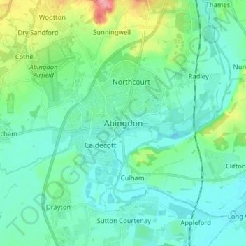
Name: Abingdon topographic map, elevation, terrain.
Average elevation: 210 ft
Minimum elevation: 148 ft
Maximum elevation: 446 ft
Other topographic maps
Click on a map to view its topography, its elevation and its terrain.
The Spinney
United Kingdom > England > Oxfordshire > Vale of White Horse > Kingston Bagpuize
Average elevation: 253 ft
Appleford-on-Thames
United Kingdom > England > Oxfordshire > Vale of White Horse
Average elevation: 167 ft
Ashdown Park
United Kingdom > England > Oxfordshire > Vale of White Horse > Ashbury
Average elevation: 607 ft
Letcombe Bassett
United Kingdom > England > Oxfordshire > Vale of White Horse
Average elevation: 581 ft
Wytham Woods
United Kingdom > England > Oxfordshire > Vale of White Horse > Farmoor
Average elevation: 276 ft
Stanford in the Vale
United Kingdom > England > Oxfordshire > Vale of White Horse
Average elevation: 259 ft
Hinton Waldrist
United Kingdom > England > Oxfordshire > Vale of White Horse
Average elevation: 249 ft
Sutton Courtenay
United Kingdom > England > Oxfordshire > Vale of White Horse
Average elevation: 184 ft
Letcombe Regis
United Kingdom > England > Oxfordshire > Vale of White Horse > Letcombe Regis
Average elevation: 548 ft
Botley and North Hinksey
United Kingdom > England > Oxfordshire > Vale of White Horse
Average elevation: 256 ft
Radley
United Kingdom > England > Oxfordshire > Vale of White Horse > Abingdon
Average elevation: 217 ft
Great Coxwell
United Kingdom > England > Oxfordshire > Vale of White Horse > Faringdon
Average elevation: 354 ft
Farmoor Reservoir
United Kingdom > England > Oxfordshire > Vale of White Horse > Cumnor
Average elevation: 226 ft
Little Lews
United Kingdom > England > Oxfordshire > Vale of White Horse > Ardington
Average elevation: 600 ft
Compton Beauchamp
United Kingdom > England > Oxfordshire > Vale of White Horse
Average elevation: 466 ft
Sunningwell
United Kingdom > England > Oxfordshire > Vale of White Horse > Abingdon
Average elevation: 315 ft
West Challow
United Kingdom > England > Oxfordshire > Vale of White Horse > West Challow
Average elevation: 295 ft
Botley and North Hinksey
United Kingdom > England > Oxfordshire > Vale of White Horse
Average elevation: 256 ft
Stanford in the Vale
United Kingdom > England > Oxfordshire > Vale of White Horse
Average elevation: 262 ft