
Make a donation
Gear up for your next adventure:
As an Amazon Associate, this site earns from qualifying purchases at no extra cost to you.
Hiva Oa topographic map
Click on the map to display elevation.
Make a donation
Gear up for your next adventure:
As an Amazon Associate, this site earns from qualifying purchases at no extra cost to you.
Hiva Oa
Hiva Oa is the largest and most fertile of the southern Marquesas islands and second only to Nuku Hiva in size. Similar to all the larger Marquesas, Hiva Oa features steep cliffs abruptly rising from the ocean to a rugged interior spine of volcanic mountains, ridges, and deep, isolated valleys. Unlike most other Polynesian islands near the equator, no fringing coral reefs protect Hiva Oa from the pounding of the ocean and only a few sheltered anchorages and sandy beaches are scattered around the coast. Travel along the shoreline is by boat as most of the coastal terrain is too rugged for roads. A few dirt roads traverse the interior and link seacoast villages and settlements. Atuona Airport is located at an elevation of 1,481 feet (451 m) on a plateau near the center of the island and has an asphalt-surfaced runway 3,986 feet (1,215 m) long with daily flights to other Marquesas islands and Tahiti.
Make a donation
Gear up for your next adventure:
As an Amazon Associate, this site earns from qualifying purchases at no extra cost to you.
About this map
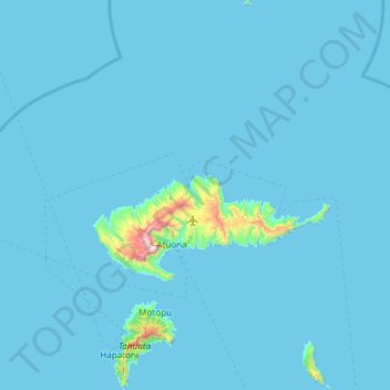
Name: Hiva Oa topographic map, elevation, terrain.
Location: Hiva Oa, Marquesas Islands, French Polynesia, France (-10.02422 -139.16389 -9.43299 -138.79678)
Average elevation: 102 ft
Minimum elevation: -23 ft
Maximum elevation: 4,098 ft
Make a donation
Gear up for your next adventure:
As an Amazon Associate, this site earns from qualifying purchases at no extra cost to you.