
Finley topographic map
Click on the map to display elevation.
About this map
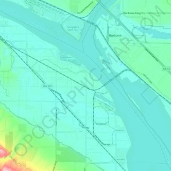
Name: Finley topographic map, elevation, terrain.
Average elevation: 377 ft
Minimum elevation: 295 ft
Maximum elevation: 863 ft
Benton County trails, hiking, mountain biking, running and outdoor activities
Other topographic maps
Click on a map to view its topography, its elevation and its terrain.
Vista
United States > Washington > Benton County > Kennewick
Native Americans populated the area around modern-day Kennewick for millennia before being discovered and settled by European descendants. These inhabitants consisted of people from the Umatilla, Wanapum, Nez Perce, and Yakama tribes. Kennewick's low elevation helped to moderate winter temperatures. On top of…
Average elevation: 558 ft