
Make a donation
Gear up for your next adventure:
As an Amazon Associate, this site earns from qualifying purchases at no extra cost to you.
Östersund topographic map
Click on the map to display elevation.
Make a donation
Gear up for your next adventure:
As an Amazon Associate, this site earns from qualifying purchases at no extra cost to you.
Östersund
Though Östersund is in fact affected by the Gulf Stream, it lacks the high frequency of rain or snow following the currents. This is due to the Scandinavian Mountain Range acting as a natural barrier, receiving most of the precipitation, giving Östersund and the surrounding area a rain deficit. Another issue that has to be taken into account is the higher elevation of Östersund compared to the weather stations in Ångermanland farther east. For example, Sollefteå at a similar latitude 130 kilometres (81 mi) to the east but near sea level in an inland valley, has three degrees warmer July days. There is often temperature inversion between Östersund and lower areas in winter.
Make a donation
Gear up for your next adventure:
As an Amazon Associate, this site earns from qualifying purchases at no extra cost to you.
About this map
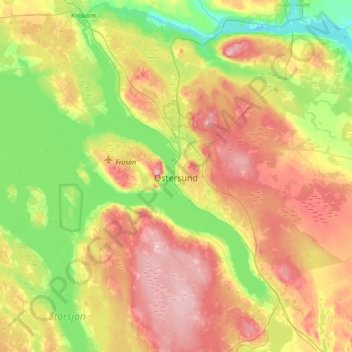
Name: Östersund topographic map, elevation, terrain.
Location: Östersund, Östersunds kommun, Jämtland County, 831 86, Sweden (63.01937 14.47571 63.33937 14.79571)
Average elevation: 1,119 ft
Minimum elevation: 814 ft
Maximum elevation: 1,555 ft
Make a donation
Gear up for your next adventure:
As an Amazon Associate, this site earns from qualifying purchases at no extra cost to you.
Other topographic maps
Click on a map to view its topography, its elevation and its terrain.
Make a donation
Gear up for your next adventure:
As an Amazon Associate, this site earns from qualifying purchases at no extra cost to you.
Make a donation
Gear up for your next adventure:
As an Amazon Associate, this site earns from qualifying purchases at no extra cost to you.
Make a donation
Gear up for your next adventure:
As an Amazon Associate, this site earns from qualifying purchases at no extra cost to you.
Make a donation
Gear up for your next adventure:
As an Amazon Associate, this site earns from qualifying purchases at no extra cost to you.