Geolocate

Centreville topographic map

Click on the map to display elevation.

About this map

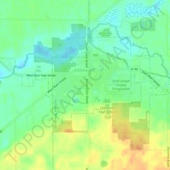
Name: Centreville topographic map, elevation, terrain.

Location: Centreville, Nottawa Township, Saint Joseph County, Michigan, United States (41.91119 -85.55107 41.92986 -85.50681)

Average elevation: 840 ft

Minimum elevation: 787 ft

Maximum elevation: 906 ft

Saint Joseph County trails, hiking, mountain biking, running and outdoor activities

Other topographic maps

Click on a map to view its topography, its elevation and its terrain.

Nottawa

United States > Michigan > Saint Joseph County

Average elevation: 843 ft

Gear up for your next adventure:

🗺️NatGeo Topo Maps - High-quality waterproof printed topographic maps of US Parks
🕶️Glacier Sunglasses - Side shields to protect eyes from high-altitude snow glare
☀️Outdoor Sunscreen - High protection sunscreen for outdoor activities
🔥Plasma Lighters - Windproof lighters that work in any weather condition
🧯Portable Fire Pit - Compact fire pit for camping spots

As an Amazon Associate, this site earns from qualifying purchases at no extra cost to you.