Geolocate

Seefeld in Tirol topographic map

Click on the map to display elevation.

About this map

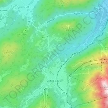
Name: Seefeld in Tirol topographic map, elevation, terrain.

Location: Seefeld in Tirol, Bezirk Innsbruck-Land, 6100, Austria (47.31939 11.16352 47.37000 11.25692)

Average elevation: 4,275 ft

Minimum elevation: 3,294 ft

Maximum elevation: 7,336 ft

Gear up for your next adventure:

👟Men's Trail Runners - Lightweight footwear for fast-paced exploration and light hiking
🔪Outdoor Multitools - Essential survival tools for gear repair and field use
🪑Ultralight Camp Chairs - Portable seating for resting after a long day of mapping
🚑Emergency Bivvies - Heat-reflective sleeping bags for survival situations
🏔️Mountain Trail Maps - High‑detail maps for popular peaks

As an Amazon Associate, this site earns from qualifying purchases at no extra cost to you.