
Make a donation
Gear up for your next adventure:
As an Amazon Associate, this site earns from qualifying purchases at no extra cost to you.
Paraíba do Sul topographic map
Click on the map to display elevation.
Make a donation
Gear up for your next adventure:
As an Amazon Associate, this site earns from qualifying purchases at no extra cost to you.
Paraíba do Sul
Located at 306 m altitude, Paraíba do Sul is located at latitude 22°09'43" south and longitude 43°17'34" west. It has an area of 582.21 square kilometres (224.79 sq mi).
Make a donation
Gear up for your next adventure:
As an Amazon Associate, this site earns from qualifying purchases at no extra cost to you.
About this map
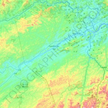
Name: Paraíba do Sul topographic map, elevation, terrain.
Average elevation: 1,680 ft
Minimum elevation: 827 ft
Maximum elevation: 4,347 ft
Make a donation
Gear up for your next adventure:
As an Amazon Associate, this site earns from qualifying purchases at no extra cost to you.
Other topographic maps
Click on a map to view its topography, its elevation and its terrain.
Petrópolis
Brazil > Rio de Janeiro > Região Metropolitana do Rio de Janeiro > Petrópolis
Average elevation: 2,241 ft