
Scotland topographic map
Click on the map to display elevation.
About this map
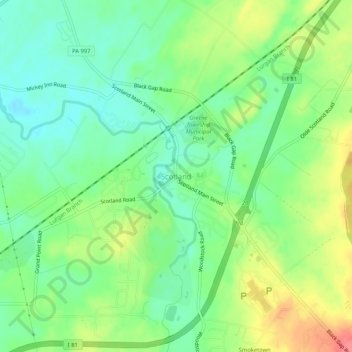
Name: Scotland topographic map, elevation, terrain.
Average elevation: 722 ft
Minimum elevation: 636 ft
Maximum elevation: 856 ft
Franklin County trails, hiking, mountain biking, running and outdoor activities
Other topographic maps
Click on a map to view its topography, its elevation and its terrain.
Fayetteville
United States > Pennsylvania > Franklin County > Greene Township > Fayetteville
Average elevation: 860 ft
Fayetteville
United States > Pennsylvania > Franklin County > Greene Township
Average elevation: 814 ft
Caledonia State Park
United States > Pennsylvania > Franklin County > Greene Township
Average elevation: 1,204 ft