
Make a donation
Gear up for your next adventure:
As an Amazon Associate, this site earns from qualifying purchases at no extra cost to you.
Provincia de Utcubamba topographic map
Click on the map to display elevation.
Make a donation
Gear up for your next adventure:
As an Amazon Associate, this site earns from qualifying purchases at no extra cost to you.
About this map
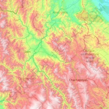
Name: Provincia de Utcubamba topographic map, elevation, terrain.
Location: Provincia de Utcubamba, Utcubamba, Amazonas, Perú (-6.76295 -79.30799 -4.76295 -77.30799)
Average elevation: 5,636 ft
Minimum elevation: 453 ft
Maximum elevation: 13,376 ft
Make a donation
Gear up for your next adventure:
As an Amazon Associate, this site earns from qualifying purchases at no extra cost to you.
Other topographic maps
Click on a map to view its topography, its elevation and its terrain.
Make a donation
Gear up for your next adventure:
As an Amazon Associate, this site earns from qualifying purchases at no extra cost to you.
Make a donation
Gear up for your next adventure:
As an Amazon Associate, this site earns from qualifying purchases at no extra cost to you.
Molinopampa
Se encuentra en el anexo de Santa Cruz del Tingo, a 6 km de distrito. Un cerro de regular elevación en la parte central, en cuyo interior habitan diversos animales silvestres y aves nocturnas. Las leyendas cuentan que aquel túnel tiene su final en algún cerro de Rioja.
Average elevation: 8,944 ft
Make a donation
Gear up for your next adventure:
As an Amazon Associate, this site earns from qualifying purchases at no extra cost to you.