Geolocate
👉 Easily get elevation data in JSON, GeoTIFF and KML formats using Elevation API
Thank you for supporting this site ❤️
Make a donation

Masturah topographic map

Click on the map to display elevation.

About this map

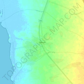
Name: Masturah topographic map, elevation, terrain.

Location: Masturah, Rabigh, Makkah Region, Saudi Arabia (23.07513 38.80164 23.15513 38.88164)

Average elevation: 26 ft

Minimum elevation: -13 ft

Maximum elevation: 69 ft

Gear up for your next adventure:

🎒Trail Energy Bars - High‑calorie bars for hiking energy
Solar GPS Watches - Advanced multisport watches with built-in topographic maps
🦶Hiking Gaiters - Keep debris and water out of your boots
🛠️Backpacking Tool Kit - Essential toolkit for outdoor repairs
🪶Survival Guide Book - Expert advice for emergency preparedness

As an Amazon Associate, this site earns from qualifying purchases at no extra cost to you.