
Central Islip topographic map
Click on the map to display elevation.
About this map
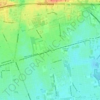
Name: Central Islip topographic map, elevation, terrain.
Average elevation: 85 ft
Minimum elevation: 36 ft
Maximum elevation: 177 ft
Suffolk County trails, hiking, mountain biking, running and outdoor activities
Other topographic maps
Click on a map to view its topography, its elevation and its terrain.
Robert Moses State Park (Long Island)
United States > New York > Suffolk County > Town of Islip
Average elevation: 0 ft
Village of Brightwaters
United States > New York > Suffolk County > Town of Islip
Average elevation: 26 ft