
Make a donation
Gear up for your next adventure:
As an Amazon Associate, this site earns from qualifying purchases at no extra cost to you.
Gargellen topographic map
Click on the map to display elevation.
Make a donation
Gear up for your next adventure:
As an Amazon Associate, this site earns from qualifying purchases at no extra cost to you.
About this map
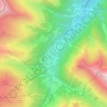
Name: Gargellen topographic map, elevation, terrain.
Average elevation: 5,902 ft
Minimum elevation: 4,072 ft
Maximum elevation: 8,238 ft
Make a donation
Gear up for your next adventure:
As an Amazon Associate, this site earns from qualifying purchases at no extra cost to you.
Other topographic maps
Click on a map to view its topography, its elevation and its terrain.
Brandnertal
Austria > Vorarlberg > Bezirk Bludenz > Brand
The Brandnertal is located in the southern part of Vorarlberg, in the far west of Austria. Adjacent to Switzerland, the Principality of Liechtenstein and Germany. In the immediate vicinity of the city of Bludenz starts the Brandnertal. From Bürs the valley rises, via Bürserberg to Brand, which is at an…
Average elevation: 5,157 ft
Make a donation
Gear up for your next adventure:
As an Amazon Associate, this site earns from qualifying purchases at no extra cost to you.
Make a donation
Gear up for your next adventure:
As an Amazon Associate, this site earns from qualifying purchases at no extra cost to you.
Make a donation
Gear up for your next adventure:
As an Amazon Associate, this site earns from qualifying purchases at no extra cost to you.
Lechquellengebirge
Austria > Vorarlberg > Bezirk Bludenz
The use of high-altitude roads (tolls) allows the motor vehicle to penetrate the interior of the mountains to a height of almost 2000 meters. But there are also larger areas with marked seclusion.
Average elevation: 5,144 ft
Marktgemeinde Schruns
Austria > Vorarlberg > Bezirk Bludenz
Schruns is a municipality in the Montafon valley (altitude 690 meters), in the Bludenz district of the westernmost Austrian state of Vorarlberg.
Average elevation: 4,511 ft
Gemeinde Lech
Austria > Vorarlberg > Bezirk Bludenz
The altitude of 1444 m for the village refers to the location of the old church on a hill. 14.1% of the municipal area is forested, 58% of the area is Alpine. Geographically and historically, Lech belongs to the Hochtannberg region, formerly Tannberg, but in terms of tourism the municipality is part of the…
Average elevation: 6,388 ft
Make a donation
Gear up for your next adventure:
As an Amazon Associate, this site earns from qualifying purchases at no extra cost to you.
Gemeinde Tschagguns
Austria > Vorarlberg > Bezirk Bludenz > Gemeinde Tschagguns
Average elevation: 5,335 ft